
Thank you for supporting this site ❤️
Make a donation
Make a donation
Lingga topographic map
Click on the map to display elevation.
Thank you for supporting this site ❤️
Make a donation
Make a donation
Lingga
Lingga is situated on the southern bank of Lupar River, with Seterap River running through the town. It has an average elevation of 3 m (9.8 ft) above the sea level.
Thank you for supporting this site ❤️
Make a donation
Make a donation
About this map
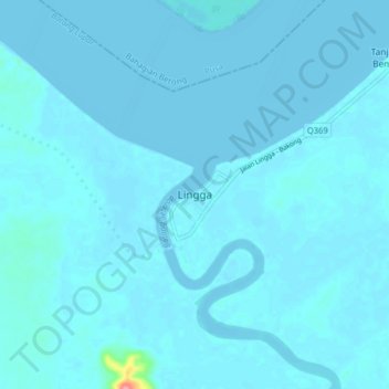
Name: Lingga topographic map, elevation, terrain.
Location: Lingga, Sri Aman, Sri Aman Division, Sarawak, Malaysia (1.31422 111.12942 1.39422 111.20942)
Average elevation: 3 m
Minimum elevation: -4 m
Maximum elevation: 90 m
Thank you for supporting this site ❤️
Make a donation
Make a donation