
Buckland topographic map
Interactive map
Click on the map to display elevation.
About this map
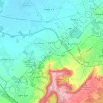
Name: Buckland topographic map, elevation, terrain.
Location: Buckland, Buckinghamshire, England, United Kingdom (51.76276 -0.74103 51.83094 -0.67750)
Average elevation: 131 m
Minimum elevation: 80 m
Maximum elevation: 270 m
Other topographic maps
Click on a map to view its topography, its elevation and its terrain.
Stokenchurch
United Kingdom > England > Buckinghamshire
Stokenchurch, Buckinghamshire, England, United Kingdom
Average elevation: 183 m
Stoke Mandeville
United Kingdom > England > Buckinghamshire
Stoke Mandeville, Buckinghamshire, England, United Kingdom
Average elevation: 99 m
Twyford
United Kingdom > England > Buckinghamshire
Twyford, Buckinghamshire, England, United Kingdom
Average elevation: 89 m