
Thank you for supporting this site ❤️
Make a donation
Make a donation
Urigoiti topographic map
Click on the map to display elevation.
Thank you for supporting this site ❤️
Make a donation
Make a donation
About this map
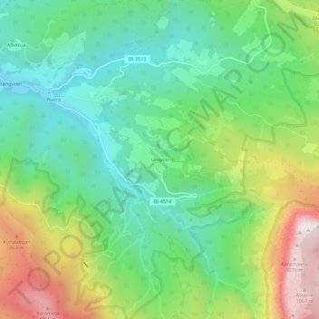
Name: Urigoiti topographic map, elevation, terrain.
Location: Urigoiti, Orozco, Vizcaya, País Vasco, 48419, España (43.06731 -2.86375 43.10731 -2.82375)
Average elevation: 516 m
Minimum elevation: 216 m
Maximum elevation: 1,089 m
Thank you for supporting this site ❤️
Make a donation
Make a donation
Other topographic maps
Click on a map to view its topography, its elevation and its terrain.