
Le Garderà topographic map
Interactive map
Click on the map to display elevation.
About this map
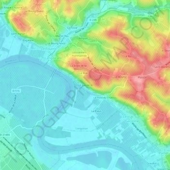
Name: Le Garderà topographic map, elevation, terrain.
Average elevation: 31 m
Minimum elevation: -2 m
Maximum elevation: 99 m
Other topographic maps
Click on a map to view its topography, its elevation and its terrain.
Château Chauvin
France > Nouvelle-Aquitaine > Gironde > Langoiran > Berquin
Château Chauvin, Chemin de Berquin, Graman, Berquin, Langoiran, Langon, Gironde, Nouvelle-Aquitaine, France métropolitaine, 33550, France
Average elevation: 58 m
Clos des Pinos
France > Nouvelle-Aquitaine > Gironde > Langoiran
Clos des Pinos, Langoiran, Langon, Gironde, Nouvelle-Aquitaine, France métropolitaine, 33550, France
Average elevation: 34 m