
Make a donation
Tate topographic map
Click on the map to display elevation.
Make a donation
About this map
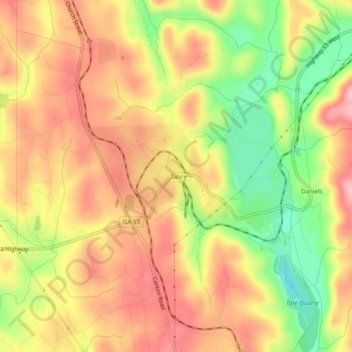
Name: Tate topographic map, elevation, terrain.
Location: Tate, Pickens County, Georgia, 30177, United States (34.39843 -84.40270 34.43843 -84.36270)
Average elevation: 368 m
Minimum elevation: 270 m
Maximum elevation: 440 m
Make a donation
Other topographic maps
Click on a map to view its topography, its elevation and its terrain.
Jasper
United States > Georgia > Pickens County
Jasper was founded in 1853 as seat of the newly formed Pickens County. It was incorporated in 1857 as a town and in 1957 as a city. The community is named for William Jasper, a hero of the American Revolutionary War. Jasper is situated at an elevation of 1,463 feet (446 m).
Average elevation: 408 m
Make a donation