
Thank you for supporting this site ❤️
Make a donation
Make a donation
Guadalupe topographic map
Click on the map to display elevation.
Thank you for supporting this site ❤️
Make a donation
Make a donation
About this map
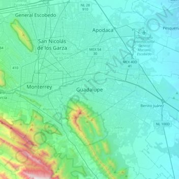
Name: Guadalupe topographic map, elevation, terrain.
Location: Guadalupe, Nuevo León, 67180, Mexico (25.51511 -100.37518 25.83511 -100.05518)
Average elevation: 594 m
Minimum elevation: 324 m
Maximum elevation: 2,477 m
Thank you for supporting this site ❤️
Make a donation
Make a donation