
Make a donation
Town of Cornwall topographic map
Click on the map to display elevation.
Make a donation
Town of Cornwall
This area of town is also mountainous and rugged, with the border descending along a northwesterly line to the narrow Woodbury Creek valley, where NY 32 and the New York State Thruway enter the town. At the valley's mouth, where Woodbury Creek drains into Moodna Creek, is the small hamlet of Mountainville, with its own fire district and ZIP Code. It gets its name from Schunemunk Mountain, where the town line climbs the northern end of Schunemunk, reaching the town's highest elevation at 1,540 feet (470 m) at the tripoint with Woodbury and Blooming Grove.
Make a donation
About this map
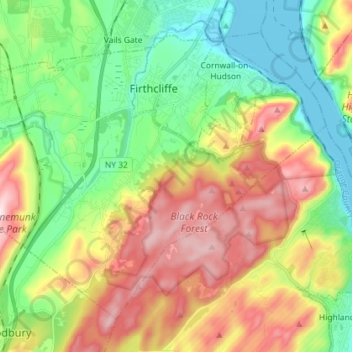
Name: Town of Cornwall topographic map, elevation, terrain.
Location: Town of Cornwall, Orange County, New York, United States (41.36849 -74.11841 41.45648 -73.97466)
Average elevation: 182 m
Minimum elevation: -2 m
Maximum elevation: 459 m
Make a donation
Other topographic maps
Click on a map to view its topography, its elevation and its terrain.
Highland Mills
United States > New York > Orange County > Village of Woodbury
Average elevation: 208 m
Make a donation
Newburgh
United States > New York > Orange County
Adjacent to Newburgh, the land rises at first sharply to a bluff, where many historic structures are located, offering sweeping views of the Hudson Highlands to the south; Mount Beacon to the east and the Newburgh—Beacon Bridge to the north; then more gradually to a relatively level western half. There are…
Average elevation: 148 m
Make a donation
Make a donation
Beaver Dam Lake
United States > New York > Orange County > Town of New Windsor
Average elevation: 118 m
Make a donation
Make a donation
Vails Gate Junction
United States > New York > Orange County > Town of New Windsor > Vails Gate
Average elevation: 92 m
Cornwall Landing
United States > New York > Orange County > Village of Cornwall-on-Hudson
Average elevation: 74 m
Nathaniel Wetlands Inventory - R5UBH - 0.09 acres
United States > New York > Orange County
Average elevation: 138 m
Make a donation