
Chassy topographic map
Interactive map
Click on the map to display elevation.
About this map
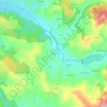
Name: Chassy topographic map, elevation, terrain.
Average elevation: 318 m
Minimum elevation: 247 m
Maximum elevation: 447 m
Other topographic maps
Click on a map to view its topography, its elevation and its terrain.
Petit Lac de Pannecière
France > Bourgogne-Franche-Comté > Nièvre > Montigny-en-Morvan > L'Huis André
Petit Lac de Pannecière, L'Huis André, Montigny-en-Morvan, Château-Chinon (Ville), Nièvre, Bourgogne-Franche-Comté, France métropolitaine, 58120, France
Average elevation: 322 m