
Thank you for supporting this site ❤️
Make a donation
Make a donation
Doncaster topographic map
Click on the map to display elevation.
Thank you for supporting this site ❤️
Make a donation
Make a donation
About this map
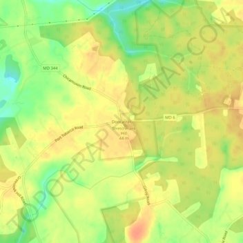
Name: Doncaster topographic map, elevation, terrain.
Location: Doncaster, Charles County, Maryland, United States (38.47797 -77.23047 38.51797 -77.19047)
Average elevation: 35 m
Minimum elevation: 9 m
Maximum elevation: 51 m
Thank you for supporting this site ❤️
Make a donation
Make a donation
Other topographic maps
Click on a map to view its topography, its elevation and its terrain.
Chapman State Park
United States > Maryland > Charles County > Indian Head > Chapman Landing
Average elevation: 19 m
Thank you for supporting this site ❤️
Make a donation
Make a donation