
Benton County topographic map
Interactive map
Click on the map to display elevation.
About this map
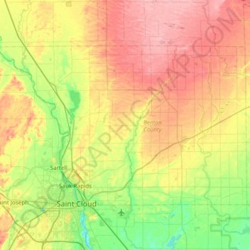
Name: Benton County topographic map, elevation, terrain.
Location: Benton County, Minnesota, USA (45.55911 -94.35320 45.82417 -93.75867)
Average elevation: 340 m
Minimum elevation: 289 m
Maximum elevation: 407 m
Other topographic maps
Click on a map to view its topography, its elevation and its terrain.
Kettle River
Kettle River, Carlton County, Minnesota, 55757, USA
Average elevation: 367 m
Lake of the Woods County
Lake of the Woods County, Minnesota, USA
Average elevation: 343 m
Keller Lake
Keller Lake, North Maplewood Drive, Maplewood, Ramsey County, Minnesota, 55109, USA
Average elevation: 272 m
Alexandria
USA > Minnesota > Alexandria
Alexandria, Douglas County, Minnesota, 56308, USA
Average elevation: 426 m