
Antony topographic map
Interactive map
Click on the map to display elevation.
About this map
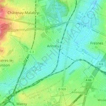
Name: Antony topographic map, elevation, terrain.
Average elevation: 76 m
Minimum elevation: 46 m
Maximum elevation: 150 m
Antony is a city in the southern suburbs of Paris in the Hurepoix and is the chief town of the arrondissement of Hauts-de-Seine - 12.2 km south of Notre-Dame Cathedral. Its altitude is 48m above sea level at the lowest point at rue Gabriel Chamon in the Bièvre Valley and 100m at the highest point in the Avenue d'Estienne d'Orves on the border with Châtenay-Malabry. Antony is at the intersection of three departments:
Other topographic maps
Click on a map to view its topography, its elevation and its terrain.
Le Plessis-Robinson
France > Ile-de-France > Hauts-de-Seine
Le Plessis-Robinson, Antony, Hauts-de-Seine, Ile-de-France, Metropolitan France, 92350, France
Average elevation: 146 m
Résidence Parc de Béarn
France > Ile-de-France > Hauts-de-Seine > Saint-Cloud
Résidence Parc de Béarn, Saint-Cloud, Arrondissement of Nanterre, Hauts-de-Seine, Ile-de-France, Metropolitan France, 92210, France
Average elevation: 71 m
Jardin de la Mairie
France > Ile-de-France > Hauts-de-Seine > Boulogne-Billancourt
Jardin de la Mairie, Centre Ville, Boulogne-Billancourt, Hauts-de-Seine, Ile-de-France, Metropolitan France, 92100, France
Average elevation: 52 m
Quartier Boieldieu
France > Ile-de-France > Hauts-de-Seine > Puteaux
Quartier Boieldieu, Puteaux, Arrondissement of Nanterre, Hauts-de-Seine, Ile-de-France, Metropolitan France, 92800, France
Average elevation: 52 m
Residence Foch
France > Ile-de-France > Hauts-de-Seine > Garches
Residence Foch, Garches, Arrondissement of Nanterre, Hauts-de-Seine, Ile-de-France, Metropolitan France, 92380, France
Average elevation: 129 m
Bois-Colombes
France > Ile-de-France > Hauts-de-Seine
Bois-Colombes, Arrondissement of Nanterre, Hauts-de-Seine, Ile-de-France, Metropolitan France, 92270, France
Average elevation: 39 m
Quartier Mont-Valérien
France > Ile-de-France > Hauts-de-Seine > Suresnes
Quartier Mont-Valérien, Suresnes, Arrondissement of Nanterre, Hauts-de-Seine, Ile-de-France, Metropolitan France, 92150, France
Average elevation: 76 m
Levallois-Perret
France > Ile-de-France > Hauts-de-Seine
Levallois-Perret, Arrondissement of Nanterre, Hauts-de-Seine, Ile-de-France, Metropolitan France, 92300, France
Average elevation: 40 m
Montrouge
France > Ile-de-France > Hauts-de-Seine
Montrouge, Antony, Hauts-de-Seine, Ile-de-France, Metropolitan France, 92120, France
Average elevation: 76 m
Puteaux
France > Ile-de-France > Hauts-de-Seine
Puteaux, Arrondissement of Nanterre, Hauts-de-Seine, Ile-de-France, Metropolitan France, 92800, France
Average elevation: 52 m
Val Saint-Olaf
France > Ile-de-France > Hauts-de-Seine > Chaville > Val Saint-Olaf
Val Saint-Olaf, Chaville, Boulogne-Billancourt, Hauts-de-Seine, Ile-de-France, Metropolitan France, 92370, France
Average elevation: 128 m
Parc de Billancourt
France > Ile-de-France > Hauts-de-Seine > Boulogne-Billancourt
Parc de Billancourt, Rives de Seine, Boulogne-Billancourt, Hauts-de-Seine, Ile-de-France, Metropolitan France, 92100, France
Average elevation: 58 m
Clamart
France > Ile-de-France > Hauts-de-Seine > Clamart > Clamart
Clamart, Antony, Hauts-de-Seine, Ile-de-France, Metropolitan France, 92140, France
Average elevation: 104 m
Villeneuve-la-Garenne
France > Ile-de-France > Hauts-de-Seine > Villeneuve-la-Garenne
Villeneuve-la-Garenne, Arrondissement of Nanterre, Hauts-de-Seine, Ile-de-France, Metropolitan France, 92390, France
Average elevation: 33 m
Bagneux
France > Ile-de-France > Hauts-de-Seine > Bagneux
Bagneux, Antony, Hauts-de-Seine, Ile-de-France, Metropolitan France, 92220, France
Average elevation: 91 m
Bois de Boulogne
France > Ile-de-France > Hauts-de-Seine > Neuilly-sur-Seine
Bois de Boulogne, Neuilly-sur-Seine, Arrondissement of Nanterre, Hauts-de-Seine, Ile-de-France, Metropolitan France, 92200, France
Average elevation: 43 m
Courbevoie
France > Ile-de-France > Hauts-de-Seine
Courbevoie, Arrondissement of Nanterre, Hauts-de-Seine, Ile-de-France, Metropolitan France, 92400, France
Average elevation: 44 m
Meudon
France > Ile-de-France > Hauts-de-Seine
Meudon, Boulogne-Billancourt, Hauts-de-Seine, Ile-de-France, Metropolitan France, France
Average elevation: 132 m
Saint-Cloud
France > Ile-de-France > Hauts-de-Seine
Saint-Cloud, Arrondissement of Nanterre, Hauts-de-Seine, Ile-de-France, Metropolitan France, 92210, France
Average elevation: 71 m
Vanves
France > Ile-de-France > Hauts-de-Seine
Vanves, Boulogne-Billancourt, Hauts-de-Seine, Ile-de-France, Metropolitan France, 92170, France
Average elevation: 67 m
Vaucresson
France > Ile-de-France > Hauts-de-Seine
Vaucresson, Arrondissement of Nanterre, Hauts-de-Seine, Ile-de-France, Metropolitan France, 92420, France
Average elevation: 157 m
Nanterre
France > Ile-de-France > Hauts-de-Seine > Nanterre
Nanterre, Arrondissement of Nanterre, Hauts-de-Seine, Ile-de-France, Metropolitan France, 92000, France
Average elevation: 45 m
Boulogne-Billancourt
France > Ile-de-France > Hauts-de-Seine
Boulogne-Billancourt, Hauts-de-Seine, Ile-de-France, Metropolitan France, 92100, France
Average elevation: 43 m
Neuilly-sur-Seine
France > Ile-de-France > Hauts-de-Seine
Neuilly-sur-Seine, Arrondissement of Nanterre, Hauts-de-Seine, Ile-de-France, Metropolitan France, 92200, France
Average elevation: 41 m
Malakoff
France > Ile-de-France > Hauts-de-Seine
Malakoff, Antony, Hauts-de-Seine, Ile-de-France, Metropolitan France, 92240, France
Average elevation: 76 m
Issy-les-Moulineaux
France > Ile-de-France > Hauts-de-Seine
Issy-les-Moulineaux, Boulogne-Billancourt, Hauts-de-Seine, Ile-de-France, Metropolitan France, 92130, France
Average elevation: 60 m