
Make a donation
Shawell topographic map
Click on the map to display elevation.
Make a donation
About this map
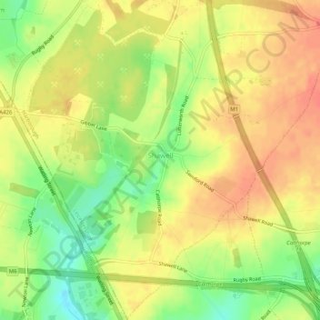
Name: Shawell topographic map, elevation, terrain.
Location: Shawell, Leicestershire, England, United Kingdom (52.40187 -1.22362 52.43262 -1.17308)
Average elevation: 127 m
Minimum elevation: 98 m
Maximum elevation: 145 m
Make a donation
Other topographic maps
Click on a map to view its topography, its elevation and its terrain.
Kegworth
United Kingdom > England > Leicestershire > North West Leicestershire
Average elevation: 47 m
Ashby-de-la-Zouch
United Kingdom > England > Leicestershire > North West Leicestershire
Average elevation: 132 m
Make a donation
Packington
United Kingdom > England > Leicestershire > North West Leicestershire
Average elevation: 119 m
Coalville
United Kingdom > England > Leicestershire > North West Leicestershire
Average elevation: 149 m
Coleorton
United Kingdom > England > Leicestershire > North West Leicestershire
Average elevation: 130 m
Make a donation
Mountsorrel
United Kingdom > England > Leicestershire > Charnwood > Mountsorrel
Average elevation: 57 m
Make a donation
Make a donation
Make a donation
Make a donation
Isley Walton
United Kingdom > England > Leicestershire > North West Leicestershire
Average elevation: 76 m
Make a donation
Markfield
United Kingdom > England > Leicestershire > Hinckley and Bosworth > Markfield
Average elevation: 174 m
Castle Donington
United Kingdom > England > Leicestershire > North West Leicestershire > Hemington
Average elevation: 56 m
Make a donation
Bottesford
United Kingdom > England > Leicestershire > Melton
Bottesford's many listed buildings include the grade I listed 13th-century Church of St Mary the Virgin. There are two scheduled monuments within the village – Fleming's Bridge and the stone cross in the Market Place. The stocks and whipping post are Grade II listed. One of the Grade II listed buildings,…
Average elevation: 39 m
Make a donation
Ratcliffe Culey
United Kingdom > England > Leicestershire > Hinckley and Bosworth
Average elevation: 77 m
South Croxton
United Kingdom > England > Leicestershire > Charnwood > South Croxton
The highest point is the church, at 120 m above mean sea level. The lowest altitude is 85 m by the Queniborough Brook.
Average elevation: 108 m
Make a donation
Thringstone
United Kingdom > England > Leicestershire > North West Leicestershire
Average elevation: 126 m
Groby
United Kingdom > England > Leicestershire > Hinckley and Bosworth > Groby
Average elevation: 107 m
Make a donation
Swannington
United Kingdom > England > Leicestershire > North West Leicestershire > Coalville
Average elevation: 132 m
Queniborough
United Kingdom > England > Leicestershire > Charnwood > Queniborough
Average elevation: 75 m
Make a donation
Make a donation
Illston on the Hill
United Kingdom > England > Leicestershire > Harborough > Illston on the Hill
Average elevation: 158 m
Make a donation
Great Glen
United Kingdom > England > Leicestershire > Harborough > Great Glen
Average elevation: 115 m
Make a donation
Stretton Baskerville
United Kingdom > England > Leicestershire > Hinckley and Bosworth
Average elevation: 111 m
Make a donation
Leicester Forest East
United Kingdom > England > Leicestershire > Leicester Forest East
Average elevation: 96 m
Breedon on the Hill
United Kingdom > England > Leicestershire > North West Leicestershire
Average elevation: 84 m
Make a donation
South Kilworth
United Kingdom > England > Leicestershire > Harborough > South Kilworth
Average elevation: 134 m
Leicestershire
United Kingdom > England > Leicestershire
A large part of the north-west of the county, around Coalville, forms part of the new National Forest area extending into Derbyshire and Staffordshire. The highest point of the county is Bardon Hill at 278 m (912 ft), which is also a Marilyn; with other hilly/upland areas of c. 150–200 metres (490–660 ft)…
Average elevation: 98 m
Make a donation
Newbold Verdon
United Kingdom > England > Leicestershire > Hinckley and Bosworth
Average elevation: 129 m
Ibstock
United Kingdom > England > Leicestershire > North West Leicestershire
Average elevation: 134 m
Whitwick
United Kingdom > England > Leicestershire > North West Leicestershire
Average elevation: 152 m
Make a donation
Burbage
United Kingdom > England > Leicestershire > Hinckley and Bosworth > Stretton Baskerville
Average elevation: 110 m
Broughton Astley
United Kingdom > England > Leicestershire > Harborough > Broughton Astley
Average elevation: 87 m
Ravenstone
United Kingdom > England > Leicestershire > North West Leicestershire
Average elevation: 143 m
Make a donation
Fenny Drayton
United Kingdom > England > Leicestershire > Hinckley and Bosworth
Average elevation: 86 m
Make a donation
Long Whatton
United Kingdom > England > Leicestershire > North West Leicestershire
Average elevation: 63 m
Barton in the Beans
United Kingdom > England > Leicestershire > Hinckley and Bosworth
Average elevation: 113 m
Higham on the Hill
United Kingdom > England > Leicestershire > Hinckley and Bosworth
Average elevation: 96 m
Timberwood Hill
United Kingdom > England > Leicestershire > North West Leicestershire
Average elevation: 192 m
Make a donation
Stoke Golding
United Kingdom > England > Leicestershire > Hinckley and Bosworth
Average elevation: 102 m
Make a donation
Make a donation
Thornton Reservoir
United Kingdom > England > Leicestershire > Hinckley and Bosworth > Thornton
Average elevation: 139 m
Merry Lees
United Kingdom > England > Leicestershire > Hinckley and Bosworth > Botcheston
Average elevation: 126 m
Make a donation