
Keratsini topographic map
Interactive map
Click on the map to display elevation.
About this map
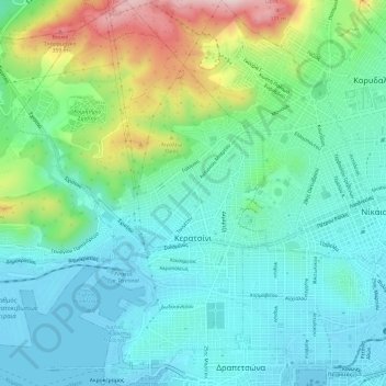
Name: Keratsini topographic map, elevation, terrain.
Average elevation: 104 m
Minimum elevation: -2 m
Maximum elevation: 409 m
Other topographic maps
Click on a map to view its topography, its elevation and its terrain.
Δήμος Νίκαιας - Αγίου Ιωάννη Ρέντη
Griechenland > Attika > Regionalbezirk Piräus
Δήμος Νίκαιας - Αγίου Ιωάννη Ρέντη, Regionalbezirk Piräus, Region Attika, Attika, Griechenland
Average elevation: 53 m