
Mahouane topographic map
Interactive map
Click on the map to display elevation.
About this map
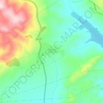
Name: Mahouane topographic map, elevation, terrain.
Location: Mahouane, El Ouricia, Daïra Aïn Arnat, Sétif, 19111, Algérie (36.24303 5.32569 36.28303 5.36569)
Average elevation: 1,193 m
Minimum elevation: 1,082 m
Maximum elevation: 1,419 m
Other topographic maps
Click on a map to view its topography, its elevation and its terrain.
Drabla
Algérie > Sétif > Daïra Aïn Arnat > El Ouricia
Drabla, El Ouricia, Daïra Aïn Arnat, Sétif, Algérie
Average elevation: 1,247 m