Geolocate

Lisbon topographic map

Interactive map

Click on the map to display elevation.

About this map

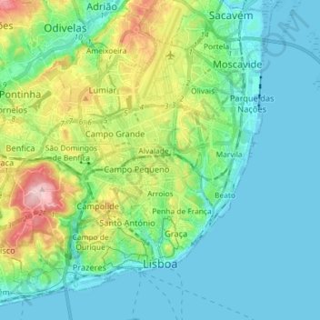
Name: Lisbon topographic map, elevation, terrain.

Location: Lisbon, Portugal (38.69140 -9.22984 38.79676 -9.08633)

Average elevation: 51 m

Minimum elevation: -4 m

Maximum elevation: 215 m

Other topographic maps

Click on a map to view its topography, its elevation and its terrain.

Cascais

Portugal > Lisbon

The settlement's prosperity led to its administrative independence from Sintra in 1364. On 7 June 1364, the people of Cascais obtained from King Peter I the elevation of the village to the status of town, necessitating the appointment of local judges and administrators. The townspeople were consequently…

Average elevation: 97 m