
Château de Rochebrune topographic map
Interactive map
Click on the map to display elevation.
About this map
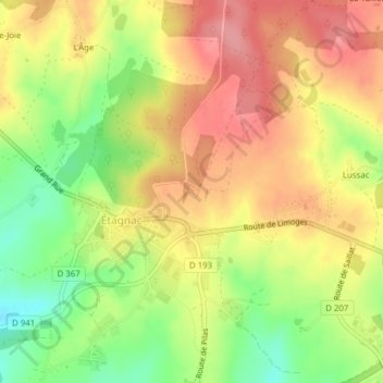
Name: Château de Rochebrune topographic map, elevation, terrain.
Average elevation: 240 m
Minimum elevation: 183 m
Maximum elevation: 285 m
Other topographic maps
Click on a map to view its topography, its elevation and its terrain.
La Tuilière
France > Nouvelle-Aquitaine > Charente > Étagnac > La Tuilière
La Tuilière, Étagnac, Confolens, Charente, Nouvelle-Aquitaine, France métropolitaine, 16150, France
Average elevation: 245 m
La Grange Neuve
France > Nouvelle-Aquitaine > Charente > Étagnac
La Grange Neuve, Étagnac, Confolens, Charente, Nouvelle-Aquitaine, France métropolitaine, 16150, France
Average elevation: 195 m