
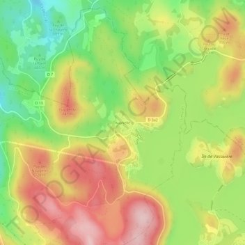
Auphelle topographic map
Interactive map
Click on the map to display elevation.
About this map
Name: Auphelle topographic map, elevation, terrain.
Average elevation: 660 m
Minimum elevation: 544 m
Maximum elevation: 774 m
Other topographic maps
Click on a map to view its topography, its elevation and its terrain.
Le Plazet
France > Nouvelle-Aquitaine > Haute-Vienne > Peyrat-le-Château
Le Plazet, Peyrat-le-Château, Limoges, Haute-Vienne, Nouvelle-Aquitaine, France métropolitaine, 87470, France
Average elevation: 467 m
Les Peyrades
France > Nouvelle-Aquitaine > Haute-Vienne > Peyrat-le-Château
Les Peyrades, Peyrat-le-Château, Limoges, Haute-Vienne, Nouvelle-Aquitaine, France métropolitaine, 87470, France
Average elevation: 665 m
Le Monteil
France > Nouvelle-Aquitaine > Haute-Vienne > Peyrat-le-Château
Le Monteil, Peyrat-le-Château, Limoges, Haute-Vienne, Nouvelle-Aquitaine, France métropolitaine, 87470, France
Average elevation: 588 m