
Thank you for supporting this site ❤️
Make a donation
Make a donation
Guilhabreu topographic map
Click on the map to display elevation.
Thank you for supporting this site ❤️
Make a donation
Make a donation
About this map
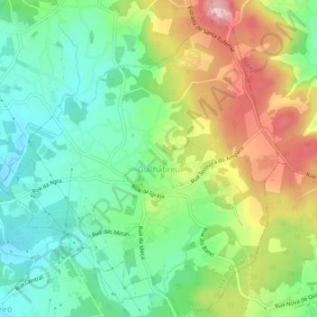
Name: Guilhabreu topographic map, elevation, terrain.
Location: Guilhabreu, Vila do Conde, Porto, Portugal (41.27925 -8.66292 41.31208 -8.62178)
Average elevation: 121 m
Minimum elevation: 50 m
Maximum elevation: 236 m
Thank you for supporting this site ❤️
Make a donation
Make a donation
Other topographic maps
Click on a map to view its topography, its elevation and its terrain.