
Make a donation
Shirakawa topographic map
Click on the map to display elevation.
Make a donation
About this map
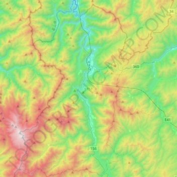
Name: Shirakawa topographic map, elevation, terrain.
Location: Shirakawa, Ono County, Gifu Prefecture, Japan (36.09301 136.76495 36.36755 136.97553)
Average elevation: 1,207 m
Minimum elevation: 347 m
Maximum elevation: 2,691 m
Make a donation
Other topographic maps
Click on a map to view its topography, its elevation and its terrain.
Shirakawa
Shirakawa is a mountain village located in far northern Gifu Prefecture, bordering Ishikawa Prefecture and Toyama Prefecture on the Ryōhaku Mountains. Mount Hakusan is the highest elevation at 2,172 metres (7,126 ft). The village's area is 95.7% mountainous forests, and its steep places are characteristic. In…
Average elevation: 667 m