Geolocate

Lynch topographic map

Interactive map

Click on the map to display elevation.

About this map

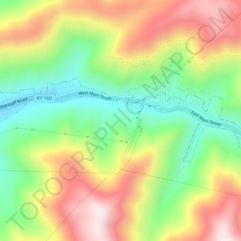
Name: Lynch topographic map, elevation, terrain.

Location: Lynch, Harlan County, Kentucky, United States (36.95704 -82.93565 36.96919 -82.89238)

Average elevation: 770 m

Minimum elevation: 487 m

Maximum elevation: 1,102 m

Lynch is located in eastern Harlan County at 36°57′54″N 82°55′00″W / 36.965133°N 82.916569°W / 36.965133; -82.916569 (36.965133, -82.916569), in the valley of Looney Creek. Lynch is the nearest city to Kentucky's highest point, Black Mountain (4,145 ft or 1,263 m). Sitting at an elevation of 1,716 feet (523 m) above sea level.

Wikipedia (CC-BY-SA 3.0)

Other topographic maps

Click on a map to view its topography, its elevation and its terrain.

Pathfork

United States > Kentucky > Harlan County

Pathfork, Harlan County, Kentucky, 40863, United States

Average elevation: 534 m

Lenarue

United States > Kentucky > Harlan County

Lenarue, Harlan County, Kentucky, 40818, United States

Average elevation: 519 m

Bardo

United States > Kentucky > Harlan County

Bardo, Harlan County, Kentucky, 40830, United States

Average elevation: 634 m

Holmes Mill

United States > Kentucky > Harlan County

Holmes Mill, Harlan County, Kentucky, 40843, United States

Average elevation: 758 m

Pansy

United States > Kentucky > Harlan County

Pansy, Harlan County, Kentucky, 40830, United States

Average elevation: 602 m

Putney

United States > Kentucky > Harlan County

Putney, Harlan County, Kentucky, 40865, United States

Average elevation: 601 m

Alva

United States > Kentucky > Harlan County

Alva, Harlan County, Kentucky, 40863, United States

Average elevation: 652 m

Yancey

United States > Kentucky > Harlan County

Yancey, Harlan County, Kentucky, 40830, United States

Average elevation: 651 m

Fresh Meadows

United States > Kentucky > Harlan County

Fresh Meadows, Harlan County, Kentucky, 40824, United States

Average elevation: 462 m

Pine Mountain

United States > Kentucky > Harlan County

Pine Mountain, Harlan County, Kentucky, United States

Average elevation: 536 m

Kenvir

United States > Kentucky > Harlan County

Kenvir, Harlan County, Kentucky, 40847, United States

Average elevation: 642 m

Ages

United States > Kentucky > Harlan County

Ages, Harlan County, Kentucky, 40801, United States

Average elevation: 587 m

Wallins Creek

United States > Kentucky > Harlan County

Wallins Creek, Harlan County, Kentucky, United States

Average elevation: 416 m

Lejunior

United States > Kentucky > Harlan County

Lejunior, Harlan County, Kentucky, 40865, United States

Average elevation: 585 m

Three Point

United States > Kentucky > Harlan County

Three Point, Harlan County, Kentucky, 40815, United States

Average elevation: 475 m

Louellen

United States > Kentucky > Harlan County

Louellen, Harlan County, Kentucky, 40849, United States

Average elevation: 698 m

Big Laurel

United States > Kentucky > Harlan County

Big Laurel, Harlan County, Kentucky, 40808, United States

Average elevation: 574 m

Cawood

United States > Kentucky > Harlan County

Cawood, Harlan County, Kentucky, 40818, United States

Average elevation: 498 m

South Wallins

United States > Kentucky > Harlan County > South Wallins

South Wallins, Harlan County, Kentucky, 40873, United States

Average elevation: 528 m

Dayhoit

United States > Kentucky > Harlan County

Dayhoit, Harlan County, Kentucky, 40824, United States

Average elevation: 462 m

Loyall

United States > Kentucky > Harlan County

Loyall, Harlan County, Kentucky, 40854, United States

Average elevation: 434 m

Molus

United States > Kentucky > Harlan County

Molus, Harlan County, Kentucky, 40819, United States

Average elevation: 467 m

Closplint

United States > Kentucky > Harlan County

Closplint, Harlan County, Kentucky, 40927, United States

Average elevation: 716 m

Benham

United States > Kentucky > Harlan County

Benham, Harlan County, Kentucky, 40807, United States

Average elevation: 667 m

Totz

United States > Kentucky > Harlan County

Totz, Harlan County, Kentucky, 40870, United States

Average elevation: 638 m

Bledsoe

United States > Kentucky > Harlan County

Bledsoe, Harlan County, Kentucky, 40810, United States

Average elevation: 604 m

Creech

United States > Kentucky > Harlan County

Creech, Harlan County, Kentucky, United States

Average elevation: 661 m

River Ridge

United States > Kentucky > Harlan County

River Ridge, Harlan County, Kentucky, 40828, United States

Average elevation: 584 m

Evarts

United States > Kentucky > Harlan County

Evarts, Harlan County, Kentucky, United States

Average elevation: 533 m

Baxter

United States > Kentucky > Harlan County

Baxter, Harlan County, Kentucky, 40806, United States

Average elevation: 468 m

Coldiron

United States > Kentucky > Harlan County

Coldiron, Harlan County, Kentucky, 40819, United States

Average elevation: 472 m

Divide

United States > Kentucky > Harlan County

Divide, Harlan County, Kentucky, 40865, United States

Average elevation: 657 m

Cranks

United States > Kentucky > Harlan County

Cranks, Harlan County, Kentucky, 40820, United States

Average elevation: 594 m

Harlan

United States > Kentucky > Harlan County

Harlan, Harlan County, Kentucky, 40831, United States

Average elevation: 493 m

Harlan

United States > Kentucky > Harlan County > Harlan > Harlan

Harlan, Harlan County, Kentucky, 40831, United States

Average elevation: 512 m

Cumberland

United States > Kentucky > Harlan County

Cumberland, Harlan County, Kentucky, 40823, United States

Average elevation: 591 m