
Make a donation
Municipio de Esquel topographic map
Click on the map to display elevation.
Make a donation
Municipio de Esquel
Owing to its location on the immediate leeward side of the Andes, Esquel has a cool summer Mediterranean climate (Köppen Csb) bordering on a Humid continental climate (Köppen Dsb). Other climate systems, such as the Trewartha climate classification, place it within the oceanic zone (Do), like much of Western Europe and the Pacific Northwest. Temperatures are relatively cold for its climate due to its higher altitude. Summers are mild with warm temperatures during the afternoon followed by cool nights. The mean temperature during the summer is around 14 °C (57.2 °F). It's the sunniest season, averaging as much as 10 hours of sunshine per day in January with an average of 7–8 clear days and only 5-7 overcast days. Spring and fall are transition seasons featuring mild temperatures during the day and cool to cold nights. Spring starts out with cool temperatures during the day and very cold nights which progressively becomes warmer. Both spring and fall have highly variable weather.
Make a donation
About this map
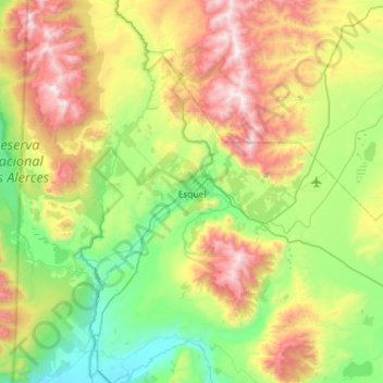
Name: Municipio de Esquel topographic map, elevation, terrain.
Average elevation: 965 m
Minimum elevation: 345 m
Maximum elevation: 2,175 m
Make a donation
Other topographic maps
Click on a map to view its topography, its elevation and its terrain.