
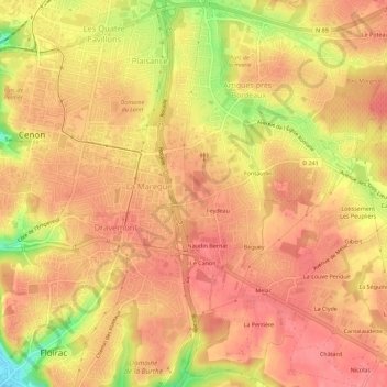
La Blancherie topographic map
Interactive map
Click on the map to display elevation.
About this map
Name: La Blancherie topographic map, elevation, terrain.
Average elevation: 61 m
Minimum elevation: 5 m
Maximum elevation: 83 m
Other topographic maps
Click on a map to view its topography, its elevation and its terrain.
Le Mirail
France > Nouvelle-Aquitaine > Gironde > Artigues-près-Bordeaux
Le Mirail, Artigues-près-Bordeaux, Bordeaux, Gironde, Nouvelle-Aquitaine, France métropolitaine, 33370, France
Average elevation: 57 m
Parc du Château Feydeau
France > Nouvelle-Aquitaine > Gironde > Artigues-près-Bordeaux
Parc du Château Feydeau, Artigues-près-Bordeaux, Bordeaux, Gironde, Nouvelle-Aquitaine, France métropolitaine, 33370, France
Average elevation: 60 m
Lormont
France > Nouvelle-Aquitaine > Gironde > Artigues-près-Bordeaux
Lormont, Artigues-près-Bordeaux, Bordeaux, Gironde, Nouvelle-Aquitaine, France métropolitaine, 33370, France
Average elevation: 42 m