
Make a donation
Arequipa topographic map
Click on the map to display elevation.
Make a donation
Arequipa
This department has a rough topography, which is characterised by heavy layers of volcanic lava covering large areas of its inter-Andean sector. It has deep canyons such as the ones formed by the Ocoña and Majes rivers. Plateaus range in height from medium, such as La Joya, and high-altitude ones such the Arrieros Pampa and those located in the zones of Chivay, Huambo and Pichucolla. Volcanic cones, such as Misti, Chachani, Ampato, Mismi, Solimana and Coropuna, emerge above the plateaus and attract snowfall. In contrast with these heights, there are deep canyons, including Majes, Colca, Sihuas and Ocoña, where important aspects of the ecological evolution of this zone can be clearly observed.
Make a donation
About this map
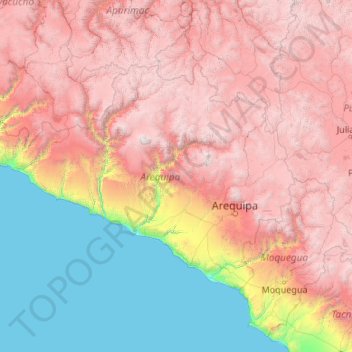
Name: Arequipa topographic map, elevation, terrain.
Location: Arequipa, Peru (-17.28501 -75.07199 -14.63274 -70.80408)
Average elevation: 2,599 m
Minimum elevation: 0 m
Maximum elevation: 6,195 m
Make a donation
Other topographic maps
Click on a map to view its topography, its elevation and its terrain.