
Massachusetts topographic map
Interactive map
Click on the map to display elevation.
About this map
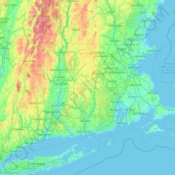
Name: Massachusetts topographic map, elevation, terrain.
Location: Massachusetts, Estados Unidos (41.18886 -73.50814 42.88678 -69.86010)
Average elevation: 128 m
Minimum elevation: -7 m
Maximum elevation: 1,159 m
Other topographic maps
Click on a map to view its topography, its elevation and its terrain.
Worcester
Estados Unidos > Massachusetts
Worcester, Massachusetts, 02895, Estados Unidos
Average elevation: 95 m