Norwich topographic map
Interactive map
Click on the map to display elevation.
About this map
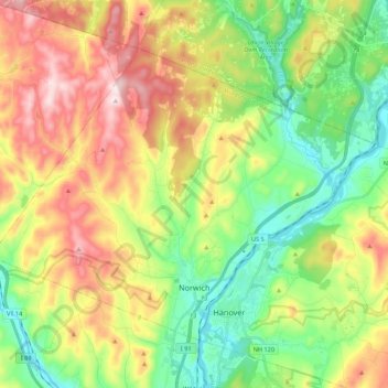
Name: Norwich topographic map, elevation, terrain.
Location: Norwich, Windsor County, Vermont, 05055, United States (43.69232 -72.42225 43.81046 -72.20540)
Average elevation: 289 m
Minimum elevation: 106 m
Maximum elevation: 559 m
The landscape is hilly and wooded. The elevation of the town center is 531 feet (162 m). The hills in the town include the 1,700-foot (520 m) Griggs Mountain in the southwestern section and the 1,853-foot (565 m) Gile Mountain in the northwestern section.
Other topographic maps
Click on a map to view its topography, its elevation and its terrain.
White River
United States > Vermont > Windsor County
White River, Windsor County, Vermont, United States
Average elevation: 419 m
The Alps
United States > Vermont > Windsor County > Reading
The Alps, Reading, Windsor County, Vermont, United States
Average elevation: 551 m
South Royalton
United States > Vermont > Windsor County
South Royalton, Royalton, Windsor County, Vermont, 05068, United States
Average elevation: 239 m
Old Baldy Mountain
United States > Vermont > Windsor County > Woodstock
Old Baldy Mountain, Woodstock, Windsor County, Vermont, 05034, United States
Average elevation: 527 m
Royalton
United States > Vermont > Windsor County
Royalton, Windsor County, Vermont, 05068, United States
Average elevation: 312 m
Barnard
United States > Vermont > Windsor County
Barnard, Windsor County, Vermont, United States
Average elevation: 463 m
Windsor
United States > Vermont > Windsor County
Windsor, Windsor County, Vermont, 05089, United States
Average elevation: 257 m
Chester
United States > Vermont > Windsor County
Chester, Windsor County, Vermont, 05143, United States
Average elevation: 317 m
West Windsor
United States > Vermont > Windsor County
West Windsor, Windsor County, Vermont, 05037, United States
Average elevation: 366 m
Springfield
United States > Vermont > Windsor County
Springfield, Windsor County, Vermont, United States
Average elevation: 238 m
Ascutney
United States > Vermont > Windsor County > Weathersfield > Ascutney
Ascutney, Weathersfield, Windsor County, Vermont, 05030, United States
Average elevation: 167 m
White River Junction
United States > Vermont > Windsor County > Hartford
White River Junction, Hartford, Windsor County, Vermont, 03784, United States
Average elevation: 160 m
Chester
United States > Vermont > Windsor County > Chester > Chester
Chester, Windsor County, Vermont, 05143, United States
Average elevation: 237 m
Rochester
United States > Vermont > Windsor County > Rochester
Rochester, Windsor County, Vermont, 05767, United States
Average elevation: 516 m
Quechee
United States > Vermont > Windsor County > Hartford
Quechee, Hartford, Windsor County, Vermont, 05059, United States
Average elevation: 231 m
Hartland
United States > Vermont > Windsor County
Hartland, Windsor County, Vermont, United States
Average elevation: 261 m
Ludlow
United States > Vermont > Windsor County
Ludlow, Windsor County, Vermont, United States
Average elevation: 496 m
Andover
United States > Vermont > Windsor County
Andover, Windsor County, Vermont, United States
Average elevation: 468 m