Geolocate

Andalusia topographic map

Interactive map

Click on the map to display elevation.

Andalusia

Andalusia sits at a latitude between 36° and 38° 44' N, in the warm-temperate region. In general, it experiences a hot-summer Mediterranean climate, with dry summers influenced by the Azores High, but subject to occasional torrential rains and extremely hot temperatures. In the winter, the tropical anticyclones move south, allowing cold polar fronts to penetrate the region. Still, within Andalusia there is considerable climatic variety. From the extensive coastal plains one may pass to the valley of the Guadalquivir, barely above sea level, then to the highest altitudes in the Iberian peninsula in the peaks of the Sierra Nevada. In a mere 50 km (31 mi) one can pass from the subtropical coast of the province of Granada to the snowy peaks of Mulhacén. Andalusia also includes both the dry Tabernas Desert in the province of Almería and the Sierra de Grazalema Natural Park in the province of Cádiz, which experiences Spain's greatest rainfall.

Wikipedia (CC-BY-SA 3.0)

About this map

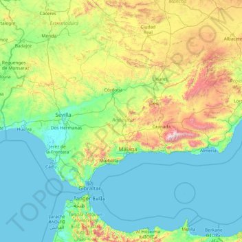
Name: Andalusia topographic map, elevation, terrain.

Location: Andalusia, Spain (35.93764 -7.52269 38.72909 -1.62980)

Average elevation: 378 m

Minimum elevation: -2 m

Maximum elevation: 3,273 m

Other topographic maps

Click on a map to view its topography, its elevation and its terrain.

Alto del Oso

Spain > Castile-La Mancha > Zafrilla

Average elevation: 1,669 m

El Jarillo

Spain > Rioja > Torre en Cameros

Average elevation: 1,236 m

Cortijo la Reina

Spain > Andalusia > Córdoba

Average elevation: 106 m

Balcó d'Alacant

Spain > Valencian Community > Tibi

Average elevation: 836 m

Belloto

Spain > Extremadura > Campanario

Average elevation: 414 m

Guaza

Spain > Canary Islands > Guaza

Average elevation: 380 m

Kanale

Spain > Basque Country > Arrankudiaga

Average elevation: 449 m

Abella

Spain > Catalonia > Abella

Average elevation: 1,270 m

León

Spain > Castile and León > León

Average elevation: 838 m

A Coruña

Spain > Galicia > A Coruña

Average elevation: 67 m

Linares

Spain > Cantabria > Castro-Urdiales

Average elevation: 416 m

Beba

Spain > Galicia > Beba

Average elevation: 343 m

La Rinconada

Spain > Andalusia > La Rinconada

Average elevation: 10 m

Tressó

Spain > Catalonia > Farrera

Average elevation: 1,855 m

Santiago de Compostela

Spain > Galicia > Santiago de Compostela

The cathedral borders the main plaza of the old and well-preserved city. According to medieval legend, the remains of the apostle James were brought to Galicia for burial; in 813, the light of a bright star guided a shepherd who was watching his flock at night to the burial site in Santiago de Compostela. This…

Average elevation: 248 m

Calp

Spain > Valencian Community > Calp > Calp

Average elevation: 74 m