
Thank you for supporting this site ❤️
Make a donation
Make a donation
Wilsonville topographic map
Click on the map to display elevation.
Thank you for supporting this site ❤️
Make a donation
Make a donation
About this map
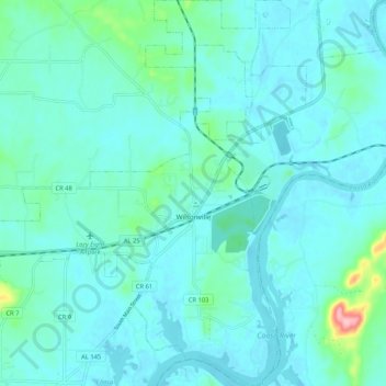
Name: Wilsonville topographic map, elevation, terrain.
Location: Wilsonville, Shelby County, Alabama, United States (33.19086 -86.53577 33.28422 -86.45717)
Average elevation: 140 m
Minimum elevation: 120 m
Maximum elevation: 270 m
Thank you for supporting this site ❤️
Make a donation
Make a donation
Other topographic maps
Click on a map to view its topography, its elevation and its terrain.
Thank you for supporting this site ❤️
Make a donation
Make a donation
Thank you for supporting this site ❤️
Make a donation
Make a donation