
Make a donation
Baden-Württemberg topographic map
Click on the map to display elevation.
Make a donation
Baden-Württemberg
The highlands and also some lower parts in the eastern side of the state, do have more temperate temperatures, especially in summer. While winters in the warmest areas often lack snow, the Black Forest, Swabian Alb and the Alps tend to get snow frequently, especially in areas of high elevation. Summers here have more rain than in the valleys, but winters tend to have more sun.
Make a donation
About this map
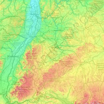
Name: Baden-Württemberg topographic map, elevation, terrain.
Location: Baden-Württemberg, Germany (47.53248 7.51175 49.79129 10.49557)
Average elevation: 442 m
Minimum elevation: 85 m
Maximum elevation: 1,846 m
Make a donation
Other topographic maps
Click on a map to view its topography, its elevation and its terrain.
Neuschwanstein Castle
Germany > Bavaria > Landkreis Ostallgäu > Hohenschwangau
The municipality of Schwangau lies at an elevation of 800 m (2,620 ft) at the southwest border of the German state of Bavaria. Its surroundings are characterised by the transition between the Alpine foothills in the south (toward the nearby Austrian border) and a hilly landscape in the north that appears flat…
Average elevation: 982 m
Make a donation
Ödinghausen
Germany > North Rhine-Westphalia > Oberbergischer Kreis > Nümbrecht
Average elevation: 280 m
Mürgen
Germany > Mecklenburg-Vorpommern > Mecklenburgische Seenplatte > Schwichtenberg
Average elevation: 10 m
Vogelsang Internationaler Platz (IP)
Germany > North Rhine-Westphalia > Kreis Euskirchen > Schleiden
Average elevation: 429 m
Hamelspringe
Germany > Lower Saxony > Landkreis Hameln-Pyrmont > Bad Münder am Deister
Average elevation: 207 m
Make a donation
Make a donation
Trupbach
Germany > North Rhine-Westphalia > Kreis Siegen-Wittgenstein > Siegen
Average elevation: 330 m
Make a donation
Make a donation
Make a donation
Ziegelhütte
Germany > Bavaria > Landkreis Wunsiedel im Fichtelgebirge > Marktredwitz
Average elevation: 563 m
Make a donation
Make a donation
Straußberg
Germany > North Rhine-Westphalia > Kreis Minden-Lübbecke > Lübbecke
Average elevation: 176 m
Make a donation
Make a donation
Petrus (12. Apostel)
Germany > Thuringia > Landkreis Schmalkalden-Meiningen > Steinbach-Hallenberg
Average elevation: 704 m
Make a donation
Topograph
Germany > Saxony > Sächsische Schweiz-Osterzgebirge > Rosenthal-Bielatal
Average elevation: 385 m
Wöhlsdorf
Germany > Thuringia > Landkreis Saalfeld-Rudolstadt > Saalfeld/Saale > Wöhlsdorf
Average elevation: 262 m
Make a donation
Schönbühl
Germany > Bavaria > Landkreis Dingolfing-Landau > Dingolfing > Kronwieden
Average elevation: 375 m
Make a donation
Make a donation