
Saint-Étienne-sous-Bailleul topographic map
Interactive map
Click on the map to display elevation.
About this map
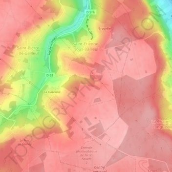
Name: Saint-Étienne-sous-Bailleul topographic map, elevation, terrain.
Average elevation: 112 m
Minimum elevation: 15 m
Maximum elevation: 143 m
Other topographic maps
Click on a map to view its topography, its elevation and its terrain.
La Garenne
France > Normandie > Eure > Saint-Étienne-sous-Bailleul > La Garenne
La Garenne, Saint-Étienne-sous-Bailleul, Les Andelys, Eure, Normandie, France métropolitaine, 27920, France
Average elevation: 115 m