
Saint Augustine topographic map
Interactive map
Click on the map to display elevation.
About this map
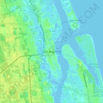
Name: Saint Augustine topographic map, elevation, terrain.
Average elevation: 5 m
Minimum elevation: -5 m
Maximum elevation: 21 m
Other topographic maps
Click on a map to view its topography, its elevation and its terrain.
Fort Peyton
United States > Florida > Saint Johns County > Saint Augustine
Fort Peyton, Saint Augustine, Saint Johns County, Florida, 32086, United States
Average elevation: 11 m
Saint Augustine Beach
United States > Florida > Saint Johns County
Saint Augustine Beach, Saint Johns County, Florida, 32080, United States
Average elevation: 3 m
Palm Valley
United States > Florida > Saint Johns County > Ponte Vedra Beach
Palm Valley, Ponte Vedra Beach, Saint Johns County, Florida, United States
Average elevation: 4 m
Ponte Vedra Beach
United States > Florida > Saint Johns County > Ponte Vedra Beach
Ponte Vedra Beach, Saint Johns County, Florida, 32250, United States
Average elevation: 3 m
Among Us Island
United States > Florida > Saint Johns County
Among Us Island, Saint Johns County, Florida, United States
Average elevation: 10 m
Lincolnville
United States > Florida > Saint Johns County > Saint Augustine
Lincolnville, Saint Augustine, Saint Johns County, Florida, 32084, United States
Average elevation: 4 m
Fruit Cove
United States > Florida > Saint Johns County > Fruit Cove
Fruit Cove, Saint Johns County, Florida, United States
Average elevation: 6 m
Saint Augustine Shores
United States > Florida > Saint Johns County > Saint Augustine Shores
Saint Augustine Shores, Saint Johns County, Florida, 32086, United States
Average elevation: 7 m
Butler Beach
United States > Florida > Saint Johns County > Butler Beach
Butler Beach, Saint Johns County, Florida, United States
Average elevation: 2 m
Saint Augustine South
United States > Florida > Saint Johns County
Saint Augustine South, Saint Johns County, Florida, United States
Average elevation: 7 m
Ponte Vedra Beach
United States > Florida > Saint Johns County > Ponte Vedra Beach
Ponte Vedra Beach, Saint Johns County, Florida, United States
Average elevation: 2 m
Nocatee
United States > Florida > Saint Johns County
Nocatee, Saint Johns County, Florida, 32081, United States
Average elevation: 7 m
West Augustine
United States > Florida > Saint Johns County > Saint Augustine
West Augustine, Saint Augustine, Saint Johns County, Florida, 32084, United States
Average elevation: 6 m
Hastings
United States > Florida > Saint Johns County
Hastings, Saint Johns County, Florida, United States
Average elevation: 4 m