
Kolhapur topographic map
Interactive map
Click on the map to display elevation.
About this map
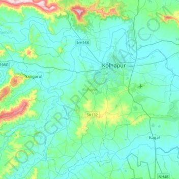
Name: Kolhapur topographic map, elevation, terrain.
Location: Kolhapur, Maharashtra, India (16.50901 74.02451 16.80996 74.35538)
Average elevation: 596 m
Minimum elevation: 532 m
Maximum elevation: 972 m
Other topographic maps
Click on a map to view its topography, its elevation and its terrain.
Chandoli National Park
India > Maharashtra > Shirala
The park spreads along the crest of the Sahyadri Range of the northern Western Ghats. It forms and protects many perennial water channels, water holes and the Vasant Sagar Reservoir. Elevation of the park ranges from 589–1,044 m (1,932–3,425 ft). The park receives its water supply from the Warna river and…
Average elevation: 749 m