
Chattanooga topographic map
Interactive map
Click on the map to display elevation.
About this map
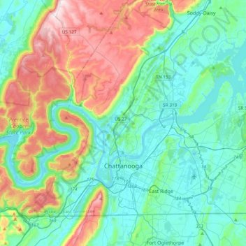
Name: Chattanooga topographic map, elevation, terrain.
Average elevation: 331 m
Minimum elevation: 189 m
Maximum elevation: 722 m
Other topographic maps
Click on a map to view its topography, its elevation and its terrain.
Falling Water
Vereinigte Staaten von Amerika > Tennessee > Hamilton County
Falling Water, Hamilton County, East Tennessee, Tennessee, Vereinigte Staaten von Amerika
Average elevation: 323 m