
Saint Maries topographic map
Interactive map
Click on the map to display elevation.
About this map
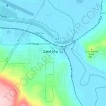
Name: Saint Maries topographic map, elevation, terrain.
Location: Saint Maries, Benewah County, Idaho, United States (47.30156 -116.59179 47.32622 -116.55449)
Average elevation: 689 m
Minimum elevation: 642 m
Maximum elevation: 927 m
Other topographic maps
Click on a map to view its topography, its elevation and its terrain.
Benewah
United States > Idaho > Benewah County
Benewah, Benewah County, Idaho, United States
Average elevation: 925 m
Fernwood
United States > Idaho > Benewah County
Fernwood, Benewah County, Idaho, 83830, United States
Average elevation: 882 m
De Smet
United States > Idaho > Benewah County
De Smet, Benewah County, Idaho, 83824, United States
Average elevation: 794 m