
Make a donation
Hutholz topographic map
Click on the map to display elevation.
Make a donation
About this map
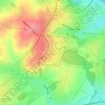
Name: Hutholz topographic map, elevation, terrain.
Location: Hutholz, Chemnitz, Sachsen, Deutschland (50.77941 12.86884 50.78982 12.89731)
Average elevation: 370 m
Minimum elevation: 319 m
Maximum elevation: 424 m
Make a donation
Other topographic maps
Click on a map to view its topography, its elevation and its terrain.
Chemnitz
Deutschland > Sachsen > Chemnitz
Chemnitz bildet mit den beiden anderen sächsischen Großstädten Leipzig und Dresden ein Städtedreieck, wobei Chemnitz den südwestlichen Eckpunkt bildet. Die Stadt liegt im Erzgebirgsbecken, umrahmt von Ausläufern des Erzgebirges im Süden und von Höhen des Mittelsächsischen Berglandes im Norden auf etwa…
Average elevation: 379 m
Make a donation
Berbisdorf
Deutschland > Sachsen > Chemnitz
Berbisdorf liegt im Süden der Stadt Chemnitz auf ca. 380–480 m ü. NN im Berbisdorfer Riedelgebiet. Nördlich befindet sich der Chemnitzer Stadtteil Harthau, östlich Einsiedel (zu welchem Berbisdorf verwaltungstechnisch gehört) und westlich Klaffenbach. Im Süden grenzt Berbisdorf an den Erzgebirgskreis.…
Average elevation: 435 m
Make a donation