Geolocate

Antimony topographic map

Interactive map

Click on the map to display elevation.

About this map

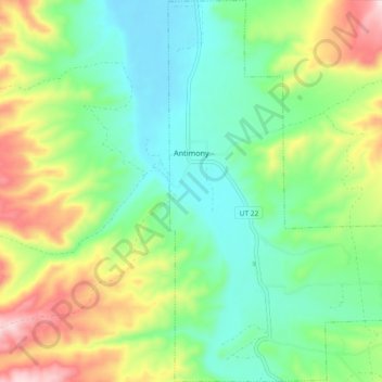
Name: Antimony topographic map, elevation, terrain.

Location: Antimony, Garfield County, Utah, 84712, United States (38.07328 -112.00529 38.14596 -111.94017)

Average elevation: 2,061 m

Minimum elevation: 1,936 m

Maximum elevation: 2,308 m

Other topographic maps

Click on a map to view its topography, its elevation and its terrain.

Hite Point

United States > Utah > Garfield County

Hite Point, Garfield County, Utah, United States

Average elevation: 1,348 m

Cannonville

United States > Utah > Garfield County

Cannonville, Garfield County, Utah, 84718, United States

Average elevation: 1,894 m

Panguitch Lake

United States > Utah > Garfield County

Panguitch Lake, Garfield County, Utah, United States

Average elevation: 2,528 m

Bryce Canyon National Park

United States > Utah > Garfield County

Bryce Canyon National Park, Garfield County, Utah, United States

Average elevation: 2,259 m

Upper Calf Creek Fall

United States > Utah > Garfield County

Upper Calf Creek Fall, Garfield County, Utah, 84716, United States

Average elevation: 1,904 m

Piracy Point

United States > Utah > Garfield County

Piracy Point, Bryce Canyon Scenic Drive, Garfield County, Utah, United States

Average elevation: 2,551 m

Henderson Creek

United States > Utah > Garfield County

Henderson Creek, Garfield County, Utah, 84776, United States

Average elevation: 2,017 m

Bryce Canyon

United States > Utah > Garfield County > Tropic

Bryce Canyon, Tropic, Garfield County, Utah, United States

Average elevation: 2,247 m

Escalante

United States > Utah > Garfield County

Escalante, Garfield County, Utah, 84726, United States

Average elevation: 1,781 m

Hatch

United States > Utah > Garfield County

Hatch, Garfield County, Utah, 84735, United States

Average elevation: 2,135 m

Bryce Canyon City

United States > Utah > Garfield County > Bryce Canyon City

Bryce Canyon City, Garfield County, Utah, 84764, United States

Average elevation: 2,337 m

Panguitch

United States > Utah > Garfield County > Panguitch

Panguitch, Garfield County, Utah, 87459, United States

Average elevation: 2,081 m

Andy Miller Flats

United States > Utah > Garfield County

Andy Miller Flats, Garfield County, Utah, United States

Average elevation: 1,604 m

Panguitch

United States > Utah > Garfield County

Panguitch, Garfield County, Utah, United States

Average elevation: 2,043 m

Capitol Reef National Park

United States > Utah > Garfield County

Capitol Reef National Park, Garfield County, Utah, United States

Average elevation: 1,963 m