
Thank you for supporting this site ❤️
Make a donation
Make a donation
Bonneval-sur-Arc topographic map
Click on the map to display elevation.
Thank you for supporting this site ❤️
Make a donation
Make a donation
Bonneval-sur-Arc
Bonneval-sur-Arc features an alpine climate due to its high elevation, just under the tree line. Its climate is characterized by very cold, snowy winters and cool, stormy summers.
Thank you for supporting this site ❤️
Make a donation
Make a donation
About this map
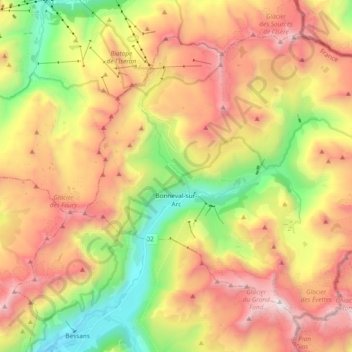
Name: Bonneval-sur-Arc topographic map, elevation, terrain.
Average elevation: 2,636 m
Minimum elevation: 1,690 m
Maximum elevation: 3,633 m
Thank you for supporting this site ❤️
Make a donation
Make a donation
Other topographic maps
Click on a map to view its topography, its elevation and its terrain.
Éboulement de Vérel
France > Auvergne-Rhône-Alpes > Savoy > Verel-Pragondran > Vérel > Les Chavannes
Average elevation: 753 m
Pointe du Villonet
France > Auvergne-Rhône-Alpes > Savoy > Saint-Colomban-des-Villards
Average elevation: 2,256 m
Rocher du Marais ou le Grand Rond
France > Auvergne-Rhône-Alpes > Savoy > Tignes
Average elevation: 2,280 m
Thank you for supporting this site ❤️
Make a donation
Make a donation