
West Malvern topographic map
Interactive map
Click on the map to display elevation.
About this map
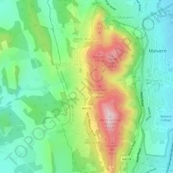
Name: West Malvern topographic map, elevation, terrain.
Location: West Malvern, Worcestershire, England, Vereinigtes Königreich (52.09534 -2.35561 52.12452 -2.33825)
Average elevation: 198 m
Minimum elevation: 80 m
Maximum elevation: 423 m
Other topographic maps
Click on a map to view its topography, its elevation and its terrain.
Bretforton
Vereinigtes Königreich > England > Worcestershire > Wychavon > Bretforton
Bretforton, Wychavon, Worcestershire, West Midlands, England, Vereinigtes Königreich
Average elevation: 42 m
West Midlands
Vereinigtes Königreich > England > Worcestershire
West Midlands, Worcestershire, West Midlands Combined Authority, England, Vereinigtes Königreich
Average elevation: 113 m