Geolocate

柞水县 topographic map

Interactive map

Click on the map to display elevation.

About this map

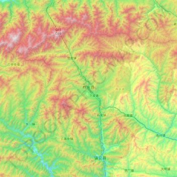
Name: 柞水县 topographic map, elevation, terrain.

Location: 柞水县, 商洛市, 陕西省, 中国 (33.42525 108.82411 33.92374 109.60339)

Average elevation: 1,320 m

Minimum elevation: 463 m

Maximum elevation: 2,863 m

柞水县地处秦岭南麓,主峰牛背梁海拔2,802.1米,境内蜿蜒曲折、沟壑纵横。

Wikipedia (CC-BY-SA 3.0)

Other topographic maps

Click on a map to view its topography, its elevation and its terrain.

月日

中国 > 陕西省 > 商洛市

月日, 商洛市, 陕西省, 中国

Average elevation: 696 m

东川镇

中国 > 陕西省 > 商洛市

东川镇, 商洛市, 陕西省, 中国

Average elevation: 938 m

黑龙口镇

中国 > 陕西省 > 商洛市

黑龙口镇, 商洛市, 陕西省, 中国

Average elevation: 1,036 m

丹凤县

中国 > 陕西省 > 商洛市

丹凤县, 商洛市, 陕西省, 中国

Average elevation: 959 m

镇安县

中国 > 陕西省 > 商洛市

镇安县, 商洛市, 陕西省, 中国

Average elevation: 1,207 m

洛南县

中国 > 陕西省 > 商洛市

洛南县, 商洛市, 陕西省, 中国

Average elevation: 1,162 m

山阳县

中国 > 陕西省 > 商洛市

山阳县, 商洛市, 陕西省, 中国

Average elevation: 987 m