
Thank you for supporting this site ❤️
Make a donation
Make a donation
Vilarandelo topographic map
Click on the map to display elevation.
Thank you for supporting this site ❤️
Make a donation
Make a donation
About this map
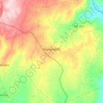
Name: Vilarandelo topographic map, elevation, terrain.
Location: Vilarandelo, Valpaços, Vila Real, 5430-651, Portugal (41.63679 -7.34098 41.68770 -7.27858)
Average elevation: 626 m
Minimum elevation: 468 m
Maximum elevation: 782 m
Thank you for supporting this site ❤️
Make a donation
Make a donation
Other topographic maps
Click on a map to view its topography, its elevation and its terrain.