
Thank you for supporting this site ❤️
Make a donation
Make a donation
Lazernij topographic map
Click on the map to display elevation.
Thank you for supporting this site ❤️
Make a donation
Make a donation
About this map
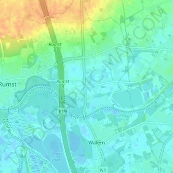
Name: Lazernij topographic map, elevation, terrain.
Location: Lazernij, Rumst, Antwerpen, Vlaanderen, 2800, België (51.05871 4.43318 51.09871 4.47318)
Average elevation: 8 m
Minimum elevation: -3 m
Maximum elevation: 32 m
Thank you for supporting this site ❤️
Make a donation
Make a donation
Other topographic maps
Click on a map to view its topography, its elevation and its terrain.
Terhagen
België > Antwerpen > Antwerpen > Rumst
Terhagen ligt aan de Rupel. De bodem is zandlemig en de hoogte varieert van 5 tot 30 meter. Het grondgebied van Terhagen is voor 50% gevormd door de steenindustrie en kleiputten. De baksteenindustrie is verdwenen in de jaren '70 van de 20e eeuw. Een museum en een groot aantal kleiputten zijn gebleven.
Average elevation: 7 m