
Zastler topographic map
Interactive map
Click on the map to display elevation.
About this map
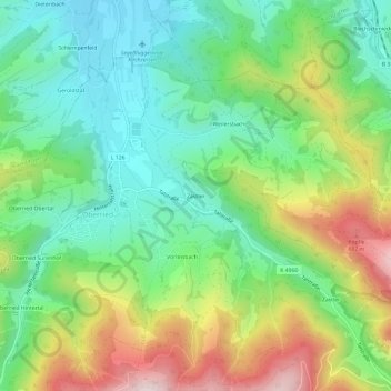
Name: Zastler topographic map, elevation, terrain.
Average elevation: 602 m
Minimum elevation: 396 m
Maximum elevation: 979 m
Other topographic maps
Click on a map to view its topography, its elevation and its terrain.
Schauinsland
Deutschland > Baden-Württemberg > Landkreis Breisgau-Hochschwarzwald > Oberried
Schauinsland, Oberried, GVV Dreisamtal, Landkreis Breisgau-Hochschwarzwald, Baden-Württemberg, 79289, Deutschland
Average elevation: 1,068 m