
Thank you for supporting this site ❤️
Make a donation
Make a donation
Paçô topographic map
Click on the map to display elevation.
Thank you for supporting this site ❤️
Make a donation
Make a donation
About this map
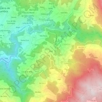
Name: Paçô topographic map, elevation, terrain.
Location: Paçô, Cepelos, Vale de Cambra, Aveiro, 3730-384, Portugal (40.82038 -8.37216 40.86038 -8.33216)
Average elevation: 479 m
Minimum elevation: 220 m
Maximum elevation: 831 m
Thank you for supporting this site ❤️
Make a donation
Make a donation