
Tamalpais-Homestead Valley topographic map
Interactive map
Click on the map to display elevation.
About this map
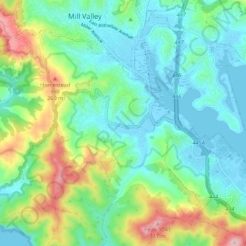
Name: Tamalpais-Homestead Valley topographic map, elevation, terrain.
Average elevation: 92 m
Minimum elevation: -4 m
Maximum elevation: 338 m
Other topographic maps
Click on a map to view its topography, its elevation and its terrain.
Strawberry
United States > California > Marin County > Mill Valley
Strawberry, Mill Valley, Marin County, CAL Fire Northern Region, California, United States
Average elevation: 20 m
Alto
United States > California > Marin County > Mill Valley
Alto, Mill Valley, Marin County, CAL Fire Northern Region, California, 94941, United States
Average elevation: 53 m