
Rosedale topographic map
Click on the map to display elevation.
About this map
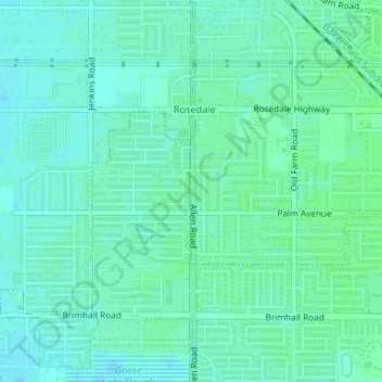
Name: Rosedale topographic map, elevation, terrain.
Location: Rosedale, Kern County, California, United States (35.37623 -119.14581 35.37924 -119.14554)
Average elevation: 113 m
Minimum elevation: 109 m
Maximum elevation: 116 m
Other topographic maps
Click on a map to view its topography, its elevation and its terrain.
Ford City
United States > California > Kern County > Taft
Ford City is a census-designated place (CDP) in Kern County, California, United States. Ford City is located 1 mile (1.61 km) north of Taft, at an elevation of 892 feet (272 m). The population was 4,348 at the 2020 census, up from 4,278 at the 2010 census. It is immediately north of Taft, between the huge…
Average elevation: 264 m
South Taft
United States > California > Kern County > Taft > South Taft
South Taft is a census-designated place (CDP) in Kern County, California, United States. South Taft is located 0.5 miles (0.8 km) south of Taft, at an elevation of 1,017 feet (310 m). The population was 2,169 at the 2010 census, up from 1,898 at the time of the 2000 census.
Average elevation: 343 m
Bodfish
United States > California > Kern County
Bodfish is located 32 miles (51 km) east-northeast of Bakersfield, at an elevation of 2,687 feet (819 m).
Average elevation: 924 m
Weedpatch
United States > California > Kern County
The community, which lies at an elevation of 387 feet (118 m), is situated off State Route 184 (Weedpatch Highway) southeast of Bakersfield, south of Lamont and about 5 miles (8 km) south of State Route 58. It is at 35°14′17″N 118°54′54″W / 35.23806°N 118.91500°W / 35.23806; -118.91500.…
Average elevation: 117 m
Inyokern
United States > California > Kern County
Inyokern (formerly Siding 16 and Magnolia) is a census-designated place (CDP) in Kern County, California, United States. Its name derives from its location near the border between Inyo and Kern Counties. Inyokern is located 8 miles (13 km) west of Ridgecrest, at an elevation of 2,434 feet (742 m). It is on the…
Average elevation: 753 m
Bakersfield
United States > California > Kern County > Bakersfield
Most of Bakersfield’s major streets are six-lane divided roads with bike lanes, with almost every street in the city having proper lane signage for bicycle traffic. Bikes are a popular method of transportation in Bakersfield, due to the city’s relatively flat topography and grid-like street system. Newer…
Average elevation: 161 m
Taft Heights
United States > California > Kern County > Taft > Taft Heights
Taft Heights (formerly, Boust City) is a census-designated place (CDP) in Kern County, California, United States. Taft Heights is located 1 mile (1.6 km) west-southwest of Taft, at an elevation of 1,178 feet (359 m). The population was 1,949 at the 2010 census, up from 1,865 at the 2000 census.
Average elevation: 368 m
Sand Canyon
United States > California > Kern County
Sand Canyon is an unincorporated community in Kern County, California. It is located on Cache Creek 7 miles (11 km) east of Tehachapi, at an elevation of 4,500 feet (1,400 m).
Average elevation: 936 m
Twin Oaks
United States > California > Kern County
Twin Oaks is an unincorporated community in Kern County, California. It is located 1.5 miles (2.4 km) east-northeast of Loraine, at an elevation of 2,825 feet (861 m).
Average elevation: 945 m
Oildale
United States > California > Kern County
Oildale is a census-designated place (CDP) in Kern County, California, United States. Oildale is located 3.5 miles (5.6 km) north-northwest of downtown Bakersfield, at an elevation of 469 feet (143 m). The population was 32,684 at the 2010 census, up from 27,885 at the 2000 census. It is an unincorporated…
Average elevation: 164 m
Stallion Springs
United States > California > Kern County > Stallion Springs
Average elevation: 1,197 m
Bealville
United States > California > Kern County
Bealville is an unincorporated community in Kern County, California. It is located on the Union Pacific Railroad (formerly Southern Pacific Railroad) 1.25 miles (2 km) south of Caliente, at an elevation of 1,811 feet (552 m). The area was named after Edward Fitzgerald Beale, who owned the adjacent Rancho El…
Average elevation: 568 m
Johannesburg
United States > California > Kern County
Johannesburg is a census-designated place (CDP) in Kern County, California, in a mining district of the Rand Mountains. Johannesburg is located 1 mile (1.6 km) east-northeast of Randsburg, at an elevation of 3,517 feet (1,072 m). The terminus of the Randsburg Railway was here from 1897 to 1933. The population…
Average elevation: 1,103 m
Woodford
United States > California > Kern County
Woodford is an unincorporated community in Kern County, California. It is located on the railroad 1 mile (1.6 km) southeast of Keene, at an elevation of 2746 feet (837 m).
Average elevation: 899 m