
Sippersfeld topographic map
Interactive map
Click on the map to display elevation.
About this map
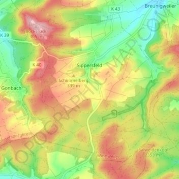
Name: Sippersfeld topographic map, elevation, terrain.
Average elevation: 322 m
Minimum elevation: 248 m
Maximum elevation: 398 m
Other topographic maps
Click on a map to view its topography, its elevation and its terrain.
Rockenhausen
Deutschland > Rheinland-Pfalz > Donnersbergkreis
Rockenhausen, Nordpfälzer Land, Donnersbergkreis, Rheinland-Pfalz, Deutschland
Average elevation: 340 m
Sankt Alban
Deutschland > Rheinland-Pfalz > Donnersbergkreis
Sankt Alban, Nordpfälzer Land, Donnersbergkreis, Rheinland-Pfalz, Deutschland
Average elevation: 312 m
Dielkirchen
Deutschland > Rheinland-Pfalz > Donnersbergkreis > Dielkirchen
Dielkirchen, Nordpfälzer Land, Donnersbergkreis, Rheinland-Pfalz, 67811, Deutschland
Average elevation: 293 m