
Thank you for supporting this site ❤️
Make a donation
Make a donation
Carviçais topographic map
Click on the map to display elevation.
Thank you for supporting this site ❤️
Make a donation
Make a donation
About this map
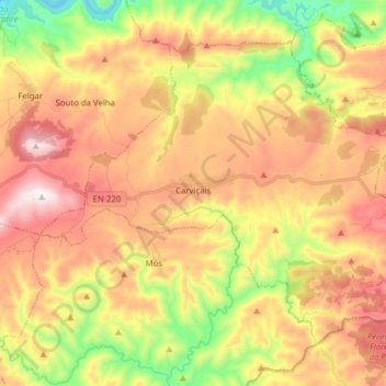
Name: Carviçais topographic map, elevation, terrain.
Location: Carviçais, Torre de Moncorvo, Distrito de Bragança, Portugal (41.13432 -6.95390 41.22658 -6.79818)
Average elevation: 538 m
Minimum elevation: 148 m
Maximum elevation: 906 m
Thank you for supporting this site ❤️
Make a donation
Make a donation
Other topographic maps
Click on a map to view its topography, its elevation and its terrain.
Barragem de Ribeiro Grande e Arco
Portugal > Distrito de Bragança > Torre de Moncorvo > Horta da Vilariça
Average elevation: 234 m
Thank you for supporting this site ❤️
Make a donation
Make a donation
Thank you for supporting this site ❤️
Make a donation
Make a donation