
Thank you for supporting this site ❤️
Make a donation
Make a donation
Devonport topographic map
Click on the map to display elevation.
Thank you for supporting this site ❤️
Make a donation
Make a donation
About this map
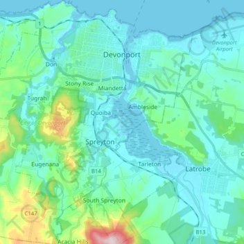
Name: Devonport topographic map, elevation, terrain.
Location: Devonport, City of Devonport, Tasmania, 7310, Australia (-41.27105 146.27702 -41.15377 146.41794)
Average elevation: 59 m
Minimum elevation: -1 m
Maximum elevation: 390 m
Thank you for supporting this site ❤️
Make a donation
Make a donation
Other topographic maps
Click on a map to view its topography, its elevation and its terrain.