
Make a donation
Hayden topographic map
Click on the map to display elevation.
Make a donation
About this map
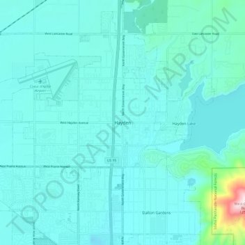
Name: Hayden topographic map, elevation, terrain.
Location: Hayden, Kootenai County, Idaho, 83835, United States (47.71906 -116.82668 47.79906 -116.74668)
Average elevation: 717 m
Minimum elevation: 654 m
Maximum elevation: 1,250 m
Make a donation
Other topographic maps
Click on a map to view its topography, its elevation and its terrain.
Hayden
United States > Idaho > Kootenai County
According to the United States Census Bureau, the city has a total area of 9.61 square miles (24.89 km2), of which 9.60 square miles (24.86 km2) is land and 0.01 square miles (0.03 km2) is water. It lies at the southwestern end of Hayden Lake, and the elevation of the city is 2,287 feet (697 m) above sea level.
Average elevation: 709 m
Make a donation
Lake Coeur d'Alene
United States > Idaho > Kootenai County > Harrison
The lake's elevation varies from 2,128 feet (649 m) above sea level in the summer to up to 7 feet (2.1 m) lower in the winter, controlled by the Post Falls Dam 9 miles (14 km) below the lake on the Spokane River.
Average elevation: 827 m
Make a donation