
Thank you for supporting this site ❤️
Make a donation
Make a donation
Outram topographic map
Click on the map to display elevation.
Thank you for supporting this site ❤️
Make a donation
Make a donation
About this map
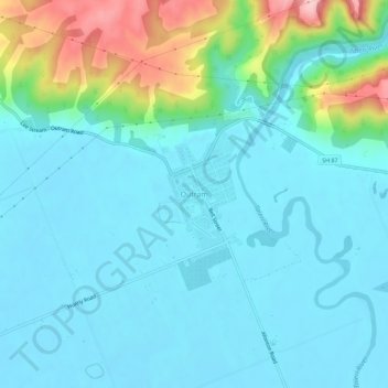
Name: Outram topographic map, elevation, terrain.
Location: Outram, Dunedin City, Otago, 9074, New Zealand (-45.87981 170.20904 -45.83981 170.24904)
Average elevation: 44 m
Minimum elevation: 3 m
Maximum elevation: 217 m
Thank you for supporting this site ❤️
Make a donation
Make a donation
Other topographic maps
Click on a map to view its topography, its elevation and its terrain.