
Time And Patience topographic map
Interactive map
Click on the map to display elevation.
About this map
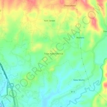
Name: Time And Patience topographic map, elevation, terrain.
Average elevation: 144 m
Minimum elevation: 104 m
Maximum elevation: 212 m
Other topographic maps
Click on a map to view its topography, its elevation and its terrain.
Guanaboa Vale
Guanaboa Vale, Saint Catherine, Middlesex County, Jamaica
Average elevation: 182 m
Bog Walk
Bog Walk, Saint Catherine, Middlesex County, Jamaica
Average elevation: 150 m
Hellshire
Hellshire, Saint Catherine, Middlesex County, Jamaica
Average elevation: 16 m
Montpelier
Jamaica > Saint Catherine > Spanish Town
Montpelier, Spanish Town, Saint Catherine, Middlesex County, Jamaica
Average elevation: 543 m
Portmore
Portmore, Saint Catherine, Middlesex County, Jamaica
Average elevation: 148 m
Spanish Town
Spanish Town, Saint Catherine, Middlesex County, Jamaica
Average elevation: 136 m